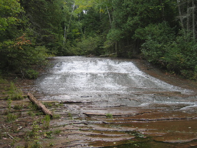
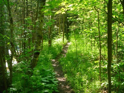
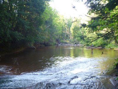
Bayfield Regional Conservancy
  • Home
    • Merger Announcement 2017
  • What We Do
    • Where We Work >
      • Strategic Conservation Plans
    • Preserve Your Land >
      • Private Land Preservation
      • Farmland Preservation
      • Land & Water Preservation
      • Start an Easement
    • Trails & Public Land Preservation >
      • Big Ravine and Nature Trail >
        • Big Ravine - Upper Section Management Plan
      • Brownstone Trail
      • Cornucopia Beach
      • Frog Bay Tribal National Park
      • Gil Larsen Nature Trail
      • Houghton Falls Nature Preserve
      • Jerry Jay Jolly Trails
      • Lincoln Community Forest >
        • Lincoln Community Forest management plan
        • Lincoln Community Forest MFL plan
      • Lost Creek Bog State Natural Area
      • Mt. Ashwabay
      • Nourse Sugarbush State Natural Area
      • White River Fisheries Area
      • North Pikes Creek Wetlands Community Forest >
        • North Pikes Creek Beaver Trapping Permit
        • NPC Presentation June 2015
        • North Pikes Creek Management Plan
    • Siskiwit River Estuary Preserve Project
    • Tyler Forks Community Forest Project
    • Geocaching
    • Northern WI Sasquatch Preserve
    • Other Initiatives & Partnerships
  • How You Can Help/Donate
    • Donate
    • Monthly Giving
    • Become a Legacy Society Member
    • Other Ways to Give
    • Volunteer With Us
    • Native Plants
  • About BRC
    • Contact Us
    • Join the Mailing List
    • Staff >
      • Join Our Team
    • Board >
      • BOARD/STAFF ONLY
    • BRC History
    • Annual Reports
    • Strategic Plan
    • Meet Our Partners
  • What's Happening
    • Articles of Merger
    • Event Calendar
    • BRC "In the News"
    • Newsletter Archive

Swenson Forest Preserve (also known as the Siskiwit River Estuary
​Preserve) Project 

Background
In the spring of 2015, following the passing of Dorothy and Dennis Swenson, Brent and Cheri (Swenson) Surowiec contacted the Bayfield Regional Conservancy about protecting their family's 95-acre property in some way while allowing for public access. In the summer of 2016, adjacent downstream landowners, Larry and Marcy Dorau, also contacted BRC about protecting their 5 acres as part of the larger project. 

The Conservancy worked with the landowners and Town of Bell to explore future ownership, management, and land protection options. Grants were pursued to acquire the property. After many meetings, in October 2017, the Town of Bell Town Board voted unanimously to pass the project on to Bayfield County as a future owner and manager. 

The Wisconsin Coastal Management Program is now working closely with NOAA's staff from the Coastal and Estuarine Land Conservation Program on a re-award of the grant to Bayfield County. This grant would cover half of the land purchase price and associated closing costs. For matching funds, both  landowners have agreed to sell their land in bargain sales. The Bayfield Regional Conservancy is currently working with the community and its membership to raise the remaining funds by spring 2018. 

Please contact the Conservancy if you would like to make a donation. 
 
If successful, Bayfield County would own and manage the property while allowing non-motorized public access. No harvesting of trees would be allowed unless for restoration or habitat improvement projects. The Bayfield Regional Conservancy will hold a conservation easement on the preserve to ensure the conservation values of the property will be protected forever.  
​
About the Property
The property is approximately 100 acres and is very diverse. It includes mixed hardwood and conifer forests, a boreal forest, over 4,000 linear feet along the Siskiwit River, a 1,200 linear foot stretch of waterfalls, a coastal estuary wetland area, several ravines, and an old apple orchard, ​

Located at the top of the Bayfield Peninsula in the Superior Coastal Plain Ecological Landscape of Wisconsin, the Siskiwit River flows into Lake Superior in the Village of Cornucopia located in the Town of Bell. The Siskiwit River Watershed covers 27 square miles and the land use is primarily forested with a small amount of agriculture.

The upper 5 miles of the river are classified by the State of Wisconsin as an Exceptional Resource Water and as a Class I trout stream, and the lower one mile segment is classified as a Class II trout stream because of the lack of spawning beds on the sandstone outcrop. The Siskiwit River coastal estuary and its surrounding forests are an outstanding natural resource and provide important habitat for fish and wildlife. These include lake-run rainbow and brown trout, chinook and coho salmon, spawning northern pike and suckers, and migratory and breeding birds.

The lower watershed is located in a Tier I and Tier II Migratory Bird Stopover area, providing habitat to waterfowl, land birds, and raptors. Additionally, the coastal wetlands in this South Shore of Lake Superior area have been identified as an Important Bird Area by the Wisconsin Bird Conservation Initiative. The lower watershed, in particular, has long been recognized both locally and throughout the region for the river and its waterfalls that flow over Orienta Brownstone shelves as an “ambassador landscape” that builds public appreciation of Lake Superior estuaries.

The Siskiwit River estuary is part of an extensive coastal wetland complex that spans much of Siskiwit Bay eventually connecting with Lost Creek Bog State Natural Area, a high quality coastal wetland located south and west of the Siskiwit River mouth.

What gets protected 
  • 100 Acres of mixed hardwood and conifer forests, and a boreal forest
  • Tier I & Tier II Migratory Bird Stopover habitat
  • Class I & II trout stream
  • 4,000 feet of Riverbank
  • Beautiful sandstone waterfalls
  • Coastal estuary wetlands
  • Habitat for rainbow and brown trout, chinook and coho salmon, northern pike and suckers, and migratory and breeding birds
  • The upper 5 miles of the river are classified by the State of Wisconsin as an Exceptional Resource Water
  • Home
    • Merger Announcement 2017
  • What We Do
    • Where We Work >
      • Strategic Conservation Plans
    • Preserve Your Land >
      • Private Land Preservation
      • Farmland Preservation
      • Land & Water Preservation
      • Start an Easement
    • Trails & Public Land Preservation >
      • Big Ravine and Nature Trail >
        • Big Ravine - Upper Section Management Plan
      • Brownstone Trail
      • Cornucopia Beach
      • Frog Bay Tribal National Park
      • Gil Larsen Nature Trail
      • Houghton Falls Nature Preserve
      • Jerry Jay Jolly Trails
      • Lincoln Community Forest >
        • Lincoln Community Forest management plan
        • Lincoln Community Forest MFL plan
      • Lost Creek Bog State Natural Area
      • Mt. Ashwabay
      • Nourse Sugarbush State Natural Area
      • White River Fisheries Area
      • North Pikes Creek Wetlands Community Forest >
        • North Pikes Creek Beaver Trapping Permit
        • NPC Presentation June 2015
        • North Pikes Creek Management Plan
    • Siskiwit River Estuary Preserve Project
    • Tyler Forks Community Forest Project
    • Geocaching
    • Northern WI Sasquatch Preserve
    • Other Initiatives & Partnerships
  • How You Can Help/Donate
    • Donate
    • Monthly Giving
    • Become a Legacy Society Member
    • Other Ways to Give
    • Volunteer With Us
    • Native Plants
  • About BRC
    • Contact Us
    • Join the Mailing List
    • Staff >
      • Join Our Team
    • Board >
      • BOARD/STAFF ONLY
    • BRC History
    • Annual Reports
    • Strategic Plan
    • Meet Our Partners
  • What's Happening
    • Articles of Merger
    • Event Calendar
    • BRC "In the News"
    • Newsletter Archive
✕